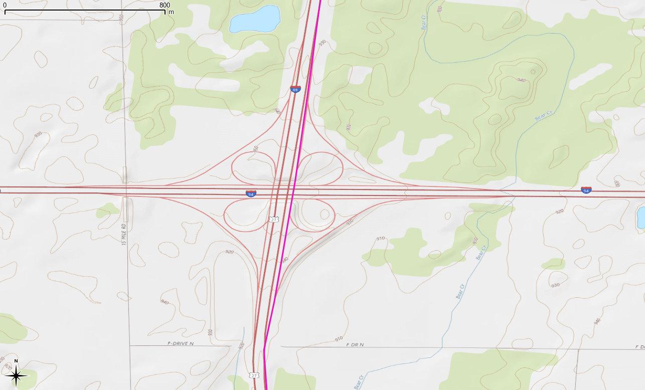
Garmin preferred route via I 69 slip-road at I 94 junction
Well, that was fun … because the slip-road at the I 69/I 94 junction in central Michigan is a slightly shorter route than continuing on the I 69, The Algorithm (which cannot be Questioned) routed me off the I 69 then back on again.
These self-driving cars, I dunno … least useful innovation ever.
Took me nine minutes to legally cross Warden Avenue. I had to walk roughly 400 m to get to a crossing, then 400 m back down the street. Straight-line distance between the bus stop and my destination is about 40 m.
(Hey! I’m not a lawyer. Read a few paragraphs of this, and it’ll be clear I shouldn’t even try to give any kind of opinion. The screenshots I include with maps.me, booking.com and Google data are presented merely for review and critique of the situation.)
An interesting discussion showed up on the OSM Legal mailing list a couple of weeks back: MAPS.ME combining OSM data and non-OSM data? OSM has some restrictions on how its data can be used. At a grossly simple level, if you mix your proprietary data in with OSM data and present a single layer map, you must either:
provide the proprietary data you mixed in under the same licence as OSM, or;
Examples of where you DO NOT need to share your non-OpenStreetMap data
…
You use OpenStreetMap as a base topographical map and make your best reasonable efforts to exclude ALL restaurants. You then add a layer of your own restaurant data.
Examples of where you DO need to share your non-OpenStreetMap data
…
You add restaurants in one area from non-OpenStreetMap data based on comparison with OpenStreetMap data in other layers.
So for this article, please bear in mind that where the above example says restaurants, I’m looking for an analogous case with hotels.
MAPS.ME (which they want you to pronounce as “maps with me”, even though it says “maps dot me”; I guess “maps ∘ me” wouldn’t make such a nice URI) is an offline map app that shows a mix of POIs over a custom-styled OSM basemap. Its publisher mixes OSM POIs with proprietary ones, and publishes a list (local copy: skipped_nodes-20160731.zip) of OSM nodes that it has skipped from its POI list. To satisfy my curiosity, I wanted to see if the required separation of data was in place with maps.me.
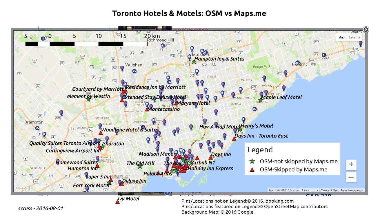
First, I used overpass turbo to return all the hotel and motel nodes in and around Toronto (the query I used was “type:node and (tourism=hotel or tourism=motel) in bbox”, saved as TorontoHotelNodes.zip). This list contains 50 hotels and motels.
Next, I used maps.me’s skipped nodes list to find the OSM hotels and motels that maps.me had omitted from their app. This list should closely match the one from booking.com, where the app company said they got their hotel data. For completeness, I queried the OSM hotels extract to see what hotels maps.me had possibly not skipped.
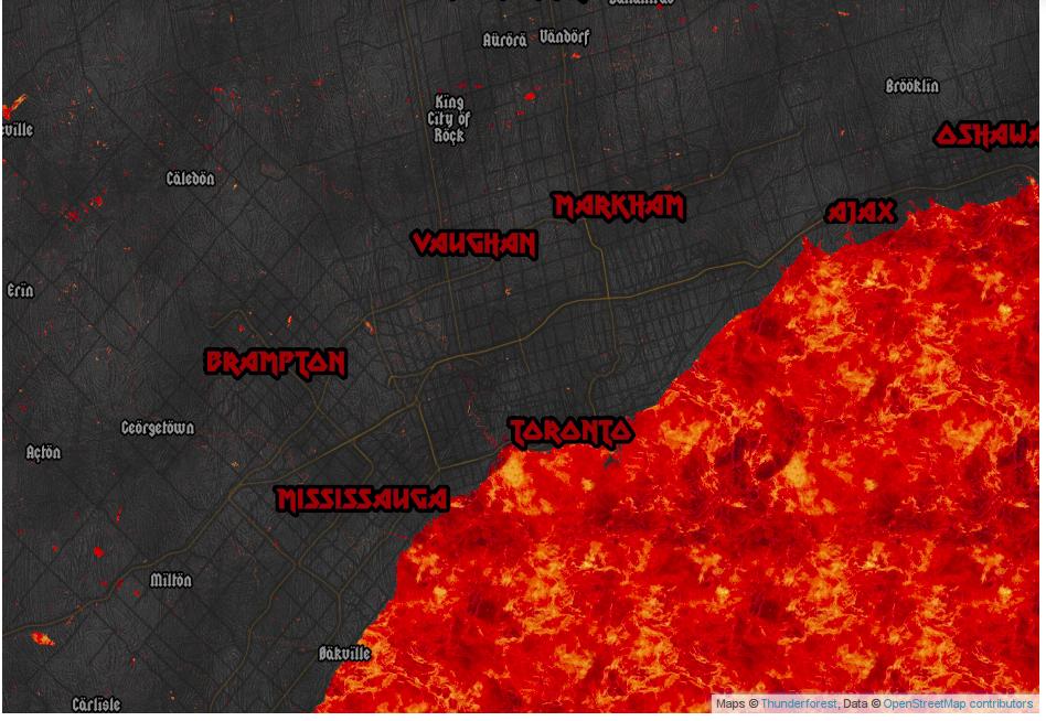
Finally, I overlaid those OSM nodes on a georeferenced screendump from booking.com’s Google map. Here’s what it looks like (click to enlarge):
So OSM nodes not skipped (which is not necessarily the same as used) by maps.me are marked ★, while those excluded by maps.me are marked ⯅. At first glance, there’s clearly not a 100% correlation between booking.com hotels, but a few clues emerge that hint strongly that maps.me are mixing in some OSM nodes with some proprietary nodes. It’s therefore likely that maps.me has not abided by the OSMF community guideline.
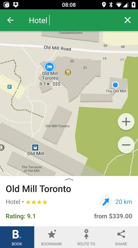
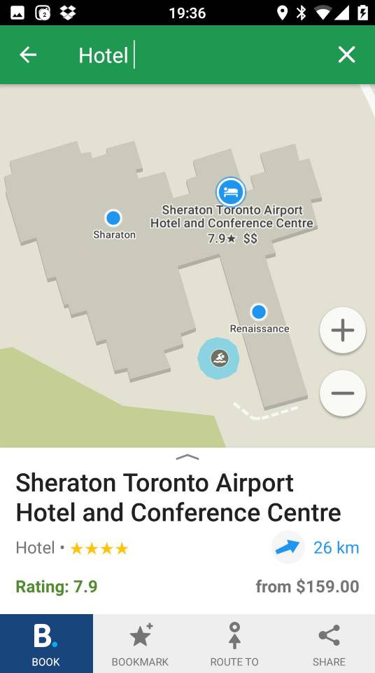
Scrolling around and zooming in on the booking.com hotel map shows that they don’t show you all of the listed properties. There’s always some filter based on location, price or availability. This makes sense if you’re managing a valuable proprietary data set, as there will always be someone trying to scrape your data and take your business with slightly cheaper referrals. One example of a hotel available on booking.com is The Old Mill (booking.com link: Old Mill Toronto) even though it’s not shown with a booking.com pin on my screenshot above. The Old Mill is also shown as not skipped on maps.me, so let’s take a look at it in the app:
Ah; there’s the booking.com property, with the OSM node off to the east under a slightly different name, and the OSM restaurant node somewhere in between. (When you search maps.me for restaurants, in Toronto at least, there are no referral links: missed opportunity there, folks!)
Since OSM is community-generated data, sometimes our spelling isn’t so great. One hotel node that leaps out from the maps.me node set is the (now fixed) “Sharaton”:
I wonder if maps.me will exclude the OSM node for this Sheraton from now on? Now that its name has been edited, if they do skip it, it means that they’re comparing OSM against a proprietary list, so would be breaking the guidelines. On the other hand, if they don’t exclude it, they really need to get a better fuzzy match algorithm, and post haste.
We can’t know the algorithm that maps.me uses to choose hotels to include referral links and skip the OSM data. The details of that are their trade secret, and no open licence can compel them to disclose it. But the cynic in me has found a possible clue in the budget motels that line Kingston Road on the eastern Toronto lake shore. Both the Days Inn – Toronto East and the Park Motel are listed on booking.com. Only the slightly more expensive Days Inn gets a referral link on maps.me. Could it be that the value of the cheaper motel’s referral isn’t worth including? (Update: this is wrong; I found another reason, which I will write about later.)
In addition, I wonder if maps.me’s skipped nodes list could be considered a “derived work” of booking.com? As the choice of nodes to skip is informed by booking.com’s data, it does give us a small insight into their database.
Growing up in a small country, I assumed the whole world used metric grid map coordinates. I mean, why would anyone bother with those tedious latitudes and longitudes when you could have your location defined by something as neat as NS539555?
The tidy, militaristic Ordnance Survey came up with the National Grid reference system, where large grid squares were given letters, and the rest of the reference was given numerically. Wikipedia gives a better graphical explanation than I could:
Illustration of the Ordnance Survey National Grid coordinate system, with Trafalgar Square as an example [CC BY-SA 3.0]
During WW2, the UK war office extended this system across most of Europe. Since most European countries didn’t use exactly the same Transverse Mercator projection as the UK did, a number of existing mapping systems were pressed into use, but using the same interleaved alphanumeric format as the OS grid reference.
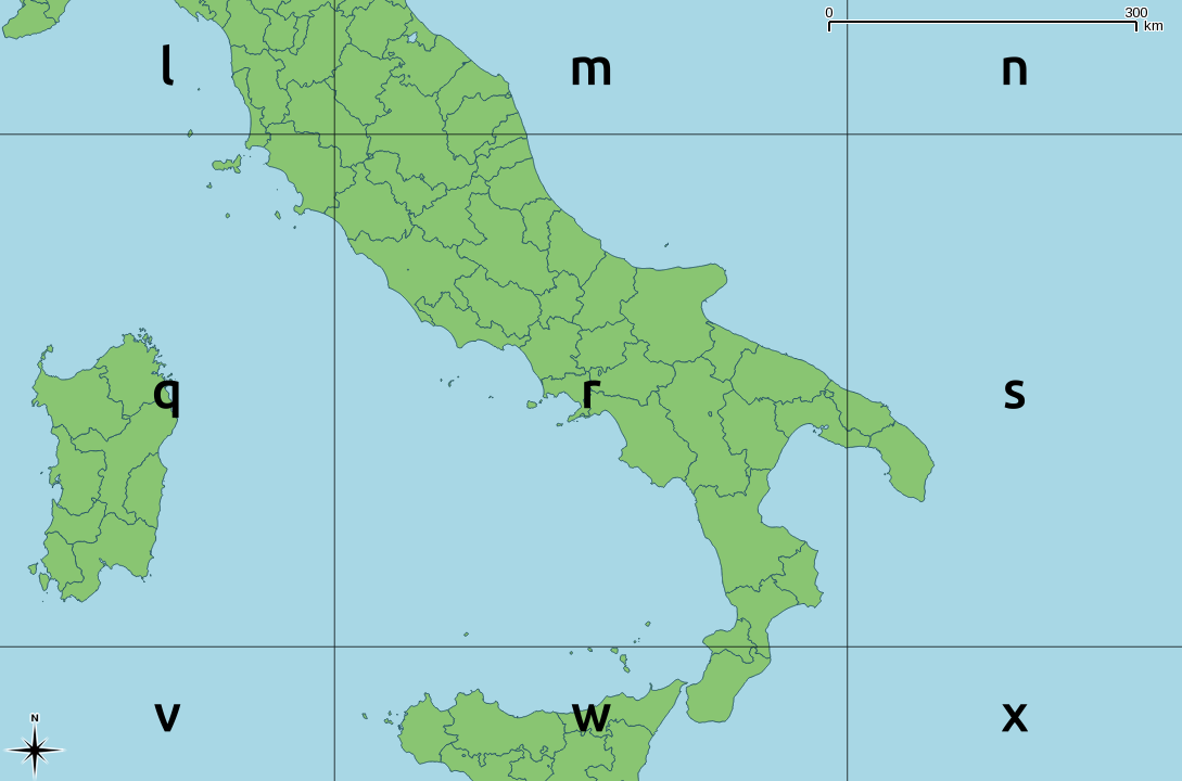
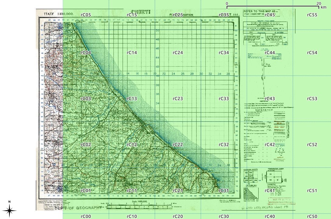
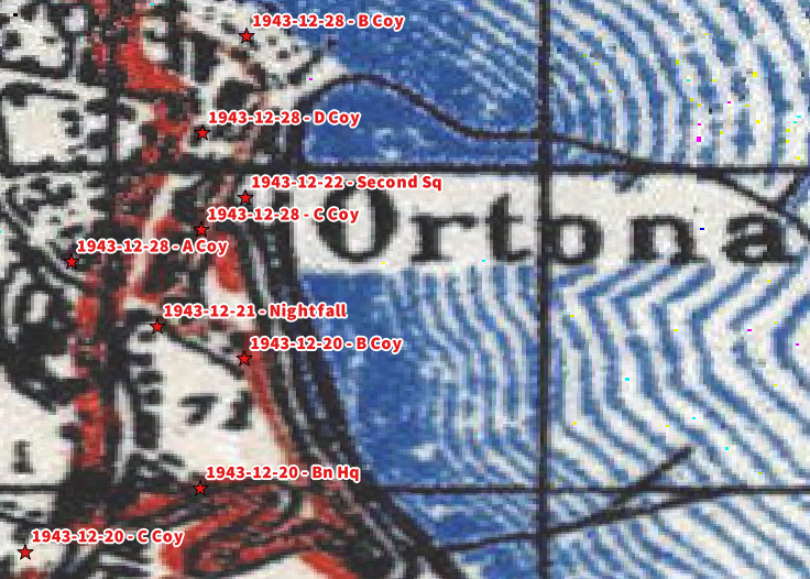
In this example, I’m going to concentrate on the South Italy zone, as that’s where I was asked to look at some war diaries from 1943. The system is similar to the OS grid, but the main difference is that the major grid reference is often given in lower case. So RN in OSGB would most often be denoted rN in the Modified British system. Both would refer to a 100 km square at (700, 700) km from the origin. (The exceedingly nitpicky might point out that RN is never used in the UK as it’s somewhere in the Atlantic, west of Ireland. To them, I say: Well, bless your heart …)
The key to both the OSGB grid and the Modified British system is a 2500 × 2500 km square, split into 25 500 km squares, and given a letter, a … z with i excluded:
Each letter encodes both an easting and a northing; so r is (500000, 500000). About the easiest way to unpack this encoding is through a simple string lookup:
result = SEARCH(letter, "VWXYZQRSTULMNOPFGHJKABCDE")-1
easting = result MOD 5
northing = INT(result / 5)
where SEARCH is a function which returns the position of a letter in a string (so SEARCH(“V”, “VWXYZ…”) returns 1).
When applied as per the GSGS South Italy system, you get something like this:
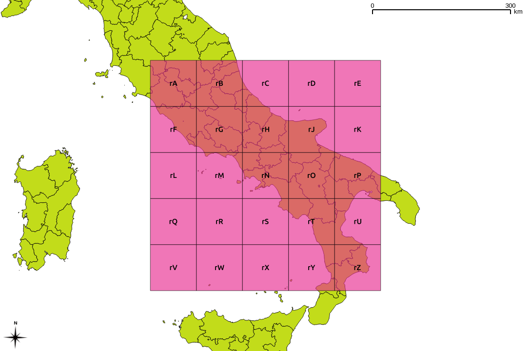
These major grid squares are in turn split into 25 minor squares of 100 km side:
Or overlaid on a map:
For grid references of higher precision, a series of numbers is appended. There should always be an even count of these numbers, for reasons which should become clear soon. Here is the rC square, split into 10 km references:
These two digit references are about the shortest/least precise you might ever see. Overlaid on an appropriate sheet from the McMaster archive WWII Topographic Map Series (which are CC BY-NC; for which, many thanks), you get:
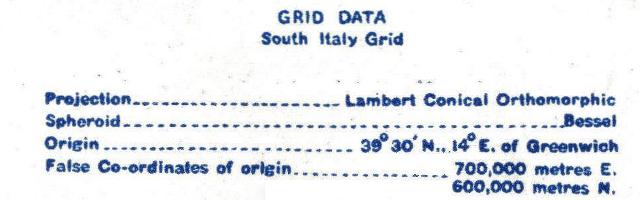
The actual projection details are given on each map:
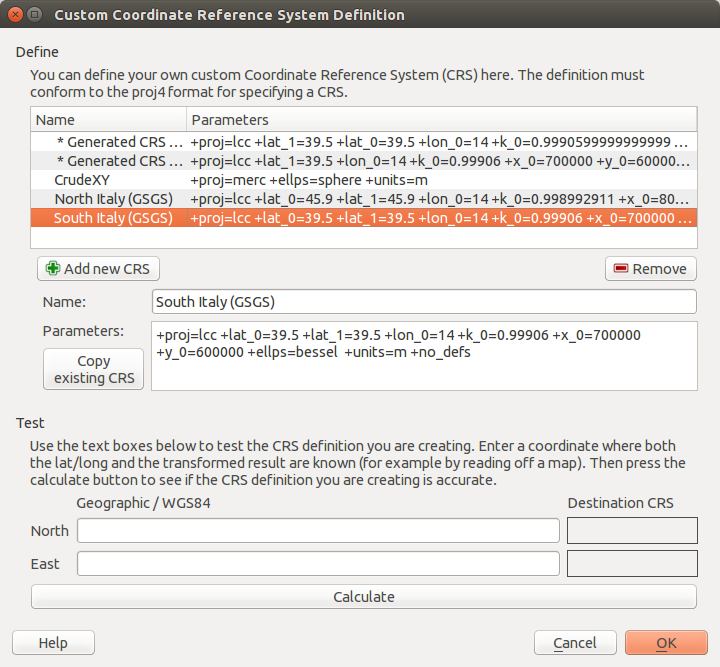
In QGIS, you can plug those values into the Custom CRS manager, and you will be able to work in these antiquated coordinate systems with ease:
I haven’t yet quite managed to work out some of the other GSGS coordinate systems. My work on North Italy is a stubborn 100 km off true, for no well-defined reason. I haven’t managed to work out unpicking alphanumeric grid references into geometries automatically, either. These will come later.
Finally, some of the coordinates you might see might not meet these specifications. In the limited survey I’ve done, I’ve noted:
references with the major grid missing, so rCxy… was written as Cxy….
references to ‘MR’ (map reference), with no alphanumeric part, such as MR 322142 (from here), which would be more correctly given as rC322142.
Huge thanks to Thierry Arsicaud, both for the great reference website, and also for the e-mail correspondence helping explain the parameters for the GSGS Italy South system. Props too to the Geographic Information Systems Stack Exchange folks for help with working out the proj.4 settings.
Hey! This is really old! The current version of Raspbian has QGIS 2.4 included in the repository. Just install that. It won’t run very fast on single-core Raspberry Pis, though.


