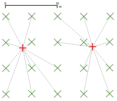
Okay, following on from my last post I geek out a lot here, so here’s a summary: In a test of 1600 images, iPhoto moved the recorded GPS location of a picture an average of 6.17m, and in one case moved the image 11.25m from its correct position.

I created a 40×40 array of points approximately 5m (okay, 5 UTM units apart, precisely) and assigned the locations to JPEG files using ExifTool. These files were imported into iPhoto, then exported. The before and after coordinates were plotted and compared:
- The green crosses are the original coordinates
- The red crosses are the coordinates assigned by iPhoto
- The dashed lines map the before coordinates to the after.
In real life, I realise it’s difficult with most consumer GPS units to resolve points 5m apart. It’s pretty egregious of Apple, however, who appear to take great pains to retain all the camera’s metadata, to mash the stored coordinates so badly.
2 replies on “More on iPhoto GPS weirdness”
Privacy concerns? I doubt they’d just randomly munge data, and Jobs has been making lots of noise about how they consider privacy more important than other companies *cough*google*cough*.
I don’t think so; you’re as likely as not to live at the 0.01′ intervals that Apple assigns. I suspect it’s deliberate truncation due to number format conversion. Exif uses a slightly weird structure to store these values (Rational64: 64-bit ints as numerator and denominator) and I bet Apple just wedged it into a convenient integer format for their metadata storage.